Planning the Summer Road Trip
It started over lunch, at a long table in the shared staff kitchen of the geography department. The air was warm with the scent of reheated soup and fresh dill.
Dalia leaned back in her chair, stretching her arms above her head. “We should really get out of the city before the semester ends. Just…go.”
Emma looked up from her salad. “You mean, like a weekend hike?”
“No,” Julia said suddenly, eyes lighting up. “A proper trip. Across Lithuania. Forests, dunes, lakes—everything.”
There was a pause. Then Tomas, who had just returned from the microwave with a steaming bowl of buckwheat, grinned. “Well, I do have the van.”
Everyone looked at him.
“It’s my uncle’s old Škoda minivan,” he explained. “Seats seven, barely drinks fuel. And I already replaced the brake pads.”
“I like this plan,” said Renata, who had dropped by to deliver a jar of jam and stayed for the company. “But only if we stop in Dzūkija. I know a mushroom foraging trail that’s better than any hiking guide could dream of.”
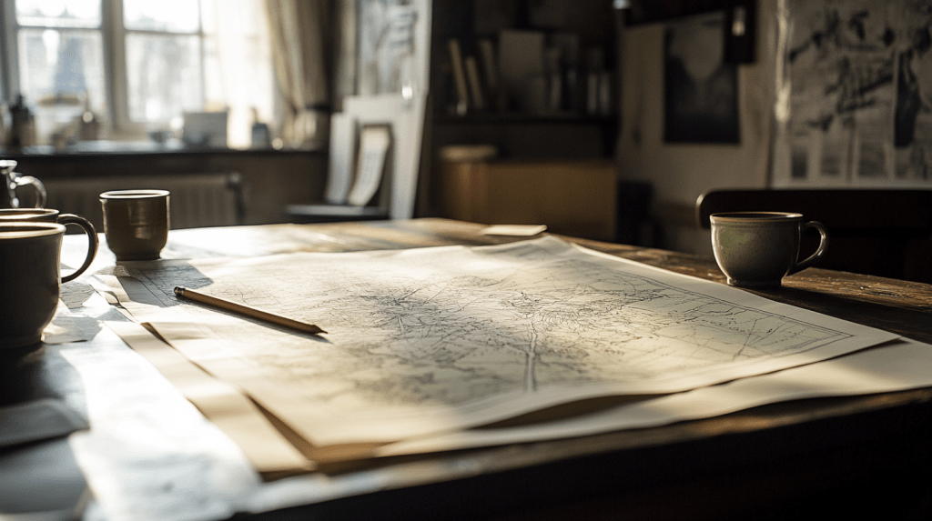
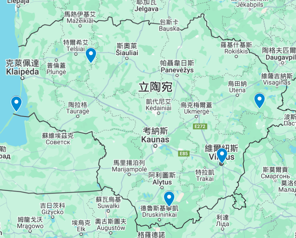
By the time the tea was poured, they had started sketching a route on the back of a research proposal printout. Forested hills in the south, lakes and towers in the northeast, the sacred hills of Šatrija, and the sand dunes near Nida. It would take ten days, maybe more.
“It’ll be like mapping the shape of summer,” Julia said quietly, tracing the curve of the Neman River on the map.
🚐 暑期旅行的發想
故事是從一頓午餐開始的,那天他們坐在地理系共享廚房的長桌旁,空氣裡瀰漫著湯與新鮮洋茴香的香味。
Dalia 倚在椅背上伸了個懶腰:「學期結束前我們真的該離開一下城市,就…出發吧。」
Emma 正在吃沙拉,抬頭問:「妳是說週末去走個步道?」
「不是,」Julia 突然說道,眼睛一亮,「是一趟真正的旅行。整個立陶宛。森林、沙丘、湖泊──全都去看看。」
現場一時安靜下來。
這時 Tomas 剛從微波爐拿回一碗熱呼呼的蕎麥粥,笑著開口:「嗯,我倒是有台車。」
大家一起看向他。
「我叔叔以前的 Škoda 小休旅,」他說,「可以坐七個人,很省油,我剛換了煞車皮。」
「我喜歡這個計劃,」Renata 說,她原本只是來送果醬,結果留了下來,「但前提是要停在 Dzukija。我知道一條私藏的採菇路線,比旅遊書上介紹的都精彩。」
等到茶水倒上時,他們已經開始在一張研究計畫的背面畫路線圖。南方的森林丘陵、東北部的湖與瞭望塔、Šatrija 的聖丘,以及 Nida 附近的沙丘。旅程大約十天,也可能更久。
「這就像是在地圖上畫出夏天的形狀,」Julia 低聲說,一邊沿著尼曼河的彎道畫下指尖。
Neman River
Emma pointed at the long curve on the map. “So this one—Neman? It goes all the way across the country?”
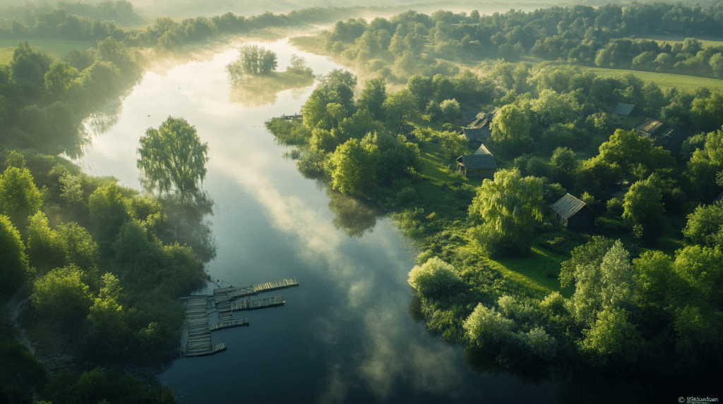
Renata nodded. “Pretty much, yeah. It starts in Belarus, cuts through southern Lithuania, then heads west into the Baltic Sea. It passes through towns like Alytus, Kaunas, Jurbarkas—some really old places. A lot of trade used to happen along the river.”
Julia asked, “Like what kind of trade?”
“Back in the day,” Renata explained, “the river was one of the main routes for timber, grain, even books. Roads weren’t great, especially in the countryside, but with a river, you could load a raft and let it carry things for days.”
Tomas added, “There were ferries, too. And floating markets. Some people even built temporary huts on boats and sold stuff as they traveled.”

Emma looked surprised. “Wait, seriously? That sounds almost like river towns in Asia.”
Renata laughed. “Maybe not that busy, but yeah, it was important. These days, though, it’s mostly quiet. Rail and highways replaced river shipping a long time ago.”
Julia said, “So the river’s still there, but it’s not used much anymore?”
“Not for transport,” Renata replied. “But you’ll still see local ferries in some towns, and people do river cruises around Kaunas, or kayaking in summer. It’s more for recreation now. But if you stand by the river early in the morning when it’s foggy—you kind of get why it meant so much.”
尼曼河
Emma 指著地圖上那條大彎,「所以這條是尼曼河?真的貫穿整個國家?」
Renata 點頭,「差不多。它從白俄羅斯流進來,穿過立陶宛南部,然後轉向西邊流到波羅的海。會經過像 Alytus、Kaunas、Jurbarkas 這些老城,很多以前的貿易就是沿著這條河走的。」
From Wiki
Julia 好奇地問:「什麼樣的貿易?」
Renata 解釋:「以前這條河是主要的運輸線之一,像木材、穀物,甚至書。當時路不好走,尤其是鄉下,但河流就方便多了,可以直接用木筏載著漂幾天。」
Tomas 補充:「那時候還有渡船、浮動市集,有些人會在船上搭臨時的棚子,一邊旅行一邊賣東西。」

Emma 有點驚訝,「真的嗎?聽起來有點像亞洲那種河上市集。」
Renata笑了笑,「可能沒那麼熱鬧啦,但以前真的很重要。現在就安靜多了,鐵路和公路早就取代了運輸功能。」
Julia 問:「那現在這條河還有在用嗎?」
「運輸的話幾乎沒有了,」Renata 說,
「但有些地方還有渡船,像 Kaunas 附近會有觀光的短程遊船,夏天也有人去划獨木舟。主要是當作休閒用途。不過如果你清晨站在河邊,起霧的時候,你會明白它為什麼曾經那麼重要。」
Trip Sketching Begins
Tomas turned the map toward himself and grabbed a pencil. “Okay, if we really want to go across the country, we need to make some choices. Lithuania looks small, but it adds up when you drive those winding roads.”
Renata leaned over, tapping the southern edge. “We definitely start in Dzūkija. Forests, mushrooms, old villages—it’s still one of the most untouched regions.”
“And Druskininkai is nearby,” Dalia added. “Hot springs, wooden villas, river walks. I’d say… two days?”
“Two and a half if we want to film or hike properly,” Julia suggested.
Tomas nodded and moved the pencil northeast. “Then we curve up toward Aukštaitija. That’s lake country—hundreds of them. We can camp or stay in a cabin.”

“Three days,” said Renata, without hesitation. “We’ll lose track of time there.”
Emma asked, “And what about the north?”
“Šiauliai and the Hill of Crosses,” Dalia said. “It’s strange and beautiful. Could be just a half-day stop.”
Tomas drew a small circle and continued west. “Then we drive to the coast—Klaipėda, Nida, the Curonian Spit. That’ll need at least three days.”
Emma smiled. “Sunset on the dunes. Sounds perfect.”
“Ten days total,” Tomas said. “Twelve if we go slow. I’d rather go slow.”
Renata grinned. “So would the river.”
Everyone laughed, and someone started boiling water for more tea.
旅行規劃初步展開
Tomas 把地圖轉向自己,拿起鉛筆說:「好,如果我們真的要橫跨整個國家,那就得開始挑地點了。立陶宛看起來不大,但小路彎來彎去,加起來也是一場長途旅行。」
Renata 指著地圖下方,「一定要從 Dzūkija 開始。那邊森林多,還有蘑菇跟老村莊,是保存最完整的地區之一。」
「而且 Druskininkai 就在附近,」Dalia 補充,「有溫泉、木造別墅、還可以沿河散步。我覺得……可以待兩天?」
「如果要拍攝或認真走步道的話,兩天半比較保險,」Julia 提出。
Tomas 點點頭,鉛筆滑向地圖的東北角。「然後往 Aukštaitija 走,那邊是湖泊地區,有上百個湖。我們可以露營或租個小木屋。」

「三天,」Renata毫不猶豫地說,「那地方很容易讓人忘記時間。」
Emma 問:「那北邊呢?」
「Šiauliai 和十字架山,」Dalia 說,「有點奇特,但很美。也許只要半天就夠。」
Tomas在地圖上畫了個小圈,然後繼續往西走,「接著開到海邊——Klaipėda、Nida、還有庫爾斯沙嘴。至少要三天。」
Emma 微笑著說:「沙丘上的日落聽起來很完美。」
「整趟大概十天,」Tomas總結,「慢一點的話十二天。我是傾向慢一點走。」
Renata 笑了笑,「河流也是這樣想的。」
大家一起笑了起來,有人走去把熱水壺重新煮起來。
The Final Addition
As the tea cooled and the afternoon sunlight slipped through the window, Julia tapped the table lightly. “Tomas also said he’s coming with us. Not just lending the van—he’ll be part of the trip.”
Emma looked up, surprised but pleased. “Really? That’s perfect. He knows so much about the places we’ll visit.”
“He even offered to take the wheel for some stretches,” Julia added. “Though we’ll all be sharing that job.”
“And we have one more person,” she continued after a pause. “Ben. He’s a visiting researcher from Ireland. You might’ve seen him in the history department lounge—tall, quiet, always with a thermos.”

Emma’s eyes lit up. “Ben? Of course. We’ve talked a few times. He’s doing research on sacred spaces in post-Soviet cities.”
The group was coming together—one scholar, one geographer, one local storyteller, a calm-eyed visitor from Ireland, a bright doctoral student, and the professor who had started it all. Not perfectly planned, but maybe better because of that.
最後加入的成員
午後的陽光斜斜落在桌面,茶漸漸涼了。Julia 輕敲了一下桌緣,「Tomas 說他會和我們一起去旅行。他不只是借車,他也會一起上路。」
Emma 抬起頭,有些驚喜地笑了,「真的?那太好了。他對我們要去的地方很熟,能有他一起走太安心了。」
「他還說可以輪流開車,」Julia 補充,「我們每個人都會輪一輪。」
她頓了頓,又說:「還有一位新成員。Ben。他是從愛爾蘭來的訪問學者。你們應該在歷史系的休息區看過他——個子高,話不多,總是帶著一個保溫壺。」
Emma 一聽眼睛就亮了,「Ben?當然認識,我們聊過幾次。他在研究蘇聯解體後的城市宗教空間。」

這個旅行團慢慢成形——一位歷史學者,一位地理學者,一位說故事的鄉村女子,一位溫和的外國訪客,一位幹練的博士生,以及促成這一切的老教授。不那麼完美規劃,卻也因此多了幾分真實與趣味。
Tracing a Route through the Summer Landscape
The plan was simple: to follow a gentle loop through the Lithuanian countryside, starting from the forested south and gradually circling west, then north, and finally east before returning to Vilnius. Each region had something distinct to offer—textures of land, echoes of memory, and colors of summer that shifted from pine to sand to water.
They would begin in Dzūkija, where pine forests whispered old stories and wild herbs waited to be gathered. From there, they’d drive northwest toward Šatrija Hill, a sacred place in the west where myth and geography intertwined. Afterward, they’d head to the coast—Nida, where winds shaped the dunes and silence drifted over the Curonian Lagoon. The final stretch would take them to the northeastern lakes of Aukštaitija, where towers overlooked still waters, and evenings came wrapped in fog and birdsong.
It wasn’t just a road trip—it was a quiet way of tracing the land’s language.
穿越夏日地景的旅程路線
他們規劃了一條簡單而圓滑的路線:從森林環繞的南方出發,順著地勢繞行西部、北部、最後回到東北,再返抵維爾紐斯。這一路上,每一個區域都擁有不同的質地、記憶的迴聲與屬於夏天的色彩——從松林的濃綠、到沙丘的金黃,再到湖水的藍。
他們會先前往 南部的 Dzūkija,那裡的松林輕語著舊時代的故事,野草藥靜靜地等著被採摘。接著轉往西北,走進 薩莫吉希亞的 Šatrija 聖丘——一處神話與地理交織的聖地。之後一路向西至海岸的 Nida,風在沙丘上刻下時間的紋路,靜謐在庫羅尼亞潟湖上輕輕飄盪。最後,他們將駛向東北的 Aukštaitija 湖區,那裡有可眺望湖面的瞭望塔,黃昏時分,霧氣與鳥鳴一同降臨。
這趟旅行不只是行駛在路上,更像是用一種安靜的方式去閱讀這片土地的語言。
Mapping the Journey
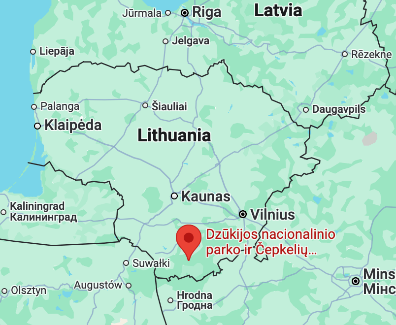
🏞️ Southern Lithuania – Forests and Hills
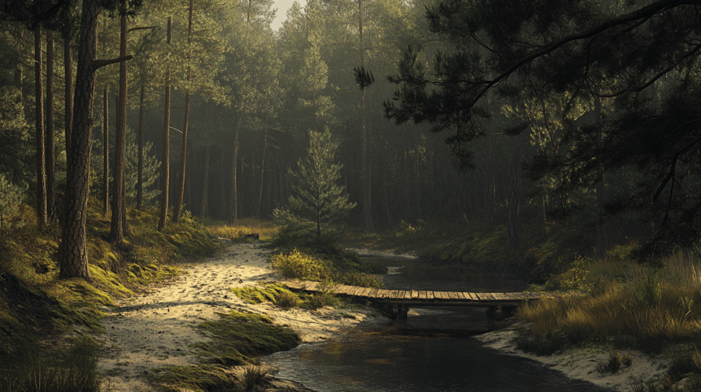
This region centers around Dzūkija National Park, known for its vast pine forests, rolling sandy paths, and quiet hills. The area is home to traditional wooden villages and offers abundant wild herbs, mushrooms, and a peaceful atmosphere for nature walks or plant foraging. In early summer, the light filtering through tall trees is especially magical.
📍 Suggested spots: Merkinė Observation Tower, Marcinkonys village, Grūda River trails.
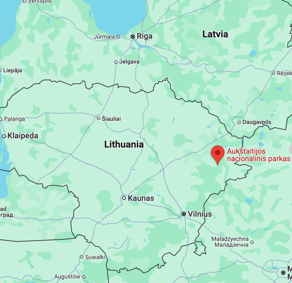
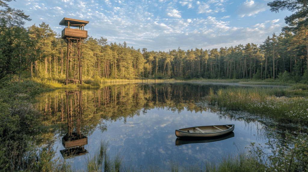
🌊 Northeastern Lithuania – Lakes and Watchtowers
In Aukštaitija National Park, you’ll find over 100 lakes nestled among pine forests. The landscape here is serene yet diverse, with multiple wooden observation towers offering sweeping views of interconnected lakes and islands. This is a dream for those who love kayaking, photography, and dusk walks.
📍 Suggested spots: Ladakalnis Viewpoint, Palūšė village, Zeimena River.
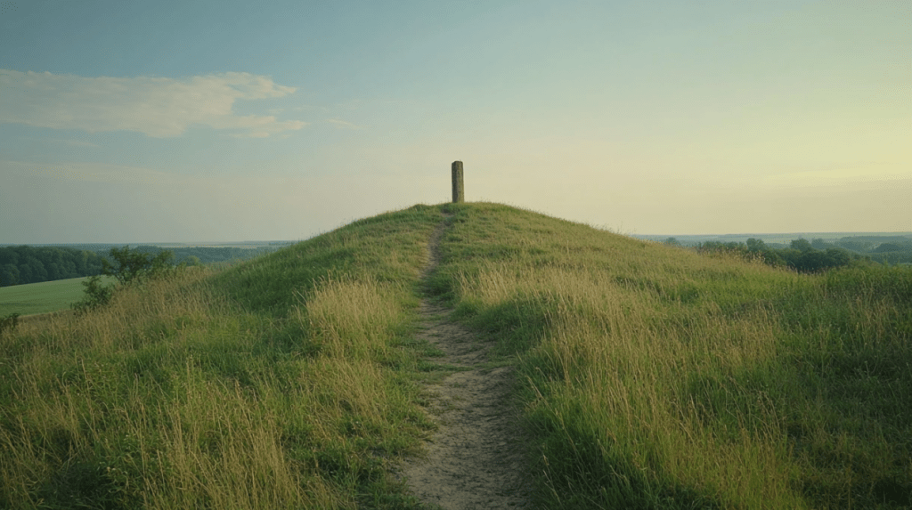
⛰️ Šatrija Hill – Sacred Ground of Samogitia
Šatrija is a hill in the western part of Lithuania, tied to ancient Baltic myths and the identity of the Samogitian region. The hill is said to resemble a reclining woman, and legends speak of witches who once gathered here. It’s a quiet place for reflection—open skies, old stones, and traces of older beliefs.
📍 Nearby village: Luokė.

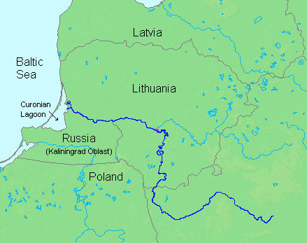
🏖️ Nida and the Curonian Spit – Dunes and the Sea
A UNESCO site and one of Lithuania’s most iconic landscapes, the Curonian Spit stretches almost 100 km between the lagoon and the Baltic Sea. Nida is the calm, picturesque town near its southern end, where soft white dunes, pine forests, and the rhythm of the sea create an unforgettable coastal experience.
📍 Suggested locations: Parnidis Dune, Dead Dunes, Nida Harbor and sundial.

計畫旅遊地點
🏞️ 立陶宛南部|森林與丘陵地帶
這個地區以 Dzūkija 國家公園 為主,擁有廣闊的松林、沙質步道與起伏的丘陵地形。這裡的村落保留著傳統木造房屋,夏季林間光影斑駁,是採集野菇與草藥、進行自然觀察與靜心散步的絕佳地點。
📍 推薦景點:Merkinė 瞭望塔、Marcinkonys 村、Grūda 河沿線步道
🌊 立陶宛東北部|湖泊與瞭望塔
這裡是立陶宛最早的自然保護區——Aukštaitija 國家公園 的範圍,擁有超過百座湖泊與茂密的針葉林。高架木塔能俯瞰湖泊交錯的壯麗景色,適合拍攝日落或進行水上活動。
📍 推薦景點:Ladakalnis 高地、Palūšė 村、Žeimena 河畔。
⛰️ Šatrija 聖丘|薩莫吉希亞的精神象徵
Šatrija 是立陶宛西部的聖地,被視為薩莫吉希亞文化的象徵。據說山丘形似一位側臥女子,過去被視為女巫集會之地,如今則保有濃厚的自然與精神氛圍,是適合冥想與靜思的場域。
📍 鄰近村落:Luokė。
🏖️ Nida 與庫羅尼亞沙洲|沙丘與海風的邊界
這是立陶宛最具代表性的地貌之一,庫羅尼亞沙洲 橫跨潟湖與波羅的海之間近百公里。南端的小鎮 Nida 有詩意的畫家風景與靜謐的沙丘。夏日的海風與松林步道為這裡增添一份清幽的魅力。
📍 推薦景點:Parnidis 沙丘、死沙丘、Nida 港口與日晷高地。


發表留言